Date: 4/27/13
Stats: 42 miles; ~13,000’ elevation gain
Time: 12:15
Background Info
The Grand Canyon Rim-To-Rim-To-Rim has been on my radar since I started trail running a few years ago. It's certainly a "bucket list" run for any trail runner, and I wanted to check it off the list sooner rather than later. Ideal conditions are found for about 1 month in the spring (usually April) and 1 month in the fall (usually October). This provides runners with moderate temperatures, lack of snow at the rim (usually), easy access to water in the canyon, and long days that allow for the entire trek to be completed in daylight.
Kyle, Drew, Zach and I left Denver early Friday morning. The excitement overshadowed the long drive and the 11 hours went by rather quickly. We stopped at a few of the lookouts on the South Rim, checked in at the visitor center to get updated info on water access, and then headed to our campsite at the Mather Campground. We discussed our plans over a couple beers and got to bed early, as the alarm clock was set for 3:50am.
 |
| map of the main corridor |
 |
| mileage and elevation info |
 |
| first views of the canyon on Friday |
 |
| dinner at the campsite |
The Run
After a quick breakfast we made our way to the visitor center where we would catch the 5am shuttle to the South Kaibab trailhead (parking was not allowed at the TH). The temperature was already 40 so we left the jackets behind. We took a few minutes to enjoy the views and take some pictures, and then shoved off at 5:30.
 |
| breakfast |
 |
| waiting for the shuttle |
 |
| S. Kaibab trailhead |
 |
| first section of the S. Kaibab trail |
S. Kaibab TH (South Rim) to Phantom Ranch
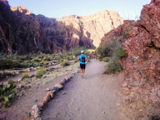
The S. Kaibab trail is one of the most amazing trails I've ever been on. We kept the pace casual as we didn't want to pound the legs too much in the early miles. The trail descends to the Colorado River, dropping about 5,000 feet in 6.5 miles.
 |
| Ooh Aah Point (seriously) |
 |
| we did not plan on wearing matching shirts |
 |
| held up for a few minutes by the mules |
 |
| the Colorado River below |
Phantom Ranch to Roaring Springs
The trail along the bottom of the canyon parallels Bright Angel Creek for approximately 7 miles. The overall trend is slightly uphill, but for the most part this entire section is run-able. We talked to a many other people who were also doing the double crossing.
 |
| it's heating up |
Roaring Springs to N. Kaibab TH (North Rim)
The climb to the north rim was beautiful, with much of the trail falling off steeply to the canyon below. The sun started to get intense and the temp rose significantly in this section.
 |
| north rim |
N. Kaibab TH (North Rim) back to Roaring Springs
The descent of N. Kaibab was much more run-able than the descent of S. Kaibab. We were quickly back at Roaring Springs to top off our water and cool off.
Roaring Springs back to Phantom Ranch
The 8ish miles back to Phantom Ranch was fairly uneventful. We definitely started to feel the heat and mileage on our legs. The overall downhill grade to Phantom Ranch helped us keep moving.
 |
| cooling off the vitals |
Phantom Ranch back to S. Kaibab TH (South Rim)
Our original intent was to ascend the Bright Angel Trail. The BA adds 2.5 miles to the ascent, but is a more shallow grade and supposedly more run-able. However, we had already been on the trail longer than expected and decided to ascend the shorter, albeit steeper, South Kaibab.
 |
| enjoying the last few miles |
 |
| almost done |
 |
| we navigated some "very dangerous trail" |
 |
| zach and me after the trek |
 |
| drew and zach in the home stretch |
 |
| zach: "what did i get myself into??" drew: "why do I keep doing this?" |
 |
| done! |
Closing Thoughts
The R2R2R is a must-do for any trail/ultra runner. I don't think anyone would argue with that. The Grand Canyon is an amazing place and I look forward to visiting again soon.
 |
| me, kyle, zach and drew |
 |
| our route |


