Date: 7/13/12-7/14/12
Stats: 102.5 miles; ~33,990’ elevation gain
Results: 29:04:00; 10th overall
(out of 140)
Background
Info
It’s hard
to believe that I completed my first ultra (also my first trail race) less than
1 year ago at Leadville and now I’m running Hardrock. That’d be like climbing
El Cap within a year of learning how to climb. Or swimming the English Channel
shortly after learning how to swim. Alright, maybe that’s a bit of an
exaggeration, but Hardrock is serious stuff. It’s the grand daddy of North American
ultras. You’ll understand why I say this when you look at the elevation
profile, historical finishing times and pictures of the course.
The
course is a big loop through the San Juan Mountains in southwestern Colorado, which
starts and ends in the small town of Silverton. The course also takes you
through the towns of Telluride and Ouray. However, most of my time at Hardrock
was spent on remote trails many miles from civilization. This is the allure of
Hardrock.
Hardrock
was first run in 1992 to commemorate the gold and silver miners from the
1800’s. The course follows the foot trails, burro trails and wagon trails which
the miners used to transport materials to and from the mining sites. This year
the course was run in the clockwise direction. It switches every year, with odd
years being run counter-clockwise. A couple extra miles were added on near
Telluride to bypass some private land.
The total
elevation change for the 102.5 miles is just shy of 68,000 feet…that’s over
twice Leadville, and easily the most of any trail race in the U.S. The average
elevation for the course is 11,200’, with the low point being 7,680’ (Ouray)
and the high point being 14,048 (Handies Peak).
 |
| course profile |
Pre-Race
Jess and
I made the drive to Silverton on Wednesday, giving me a less than desired 1.5
days to acclimate. Coming from Denver, as opposed to sea level, definitely
helps. But the thin air was definitely noticeable when we stepped out of the
car in Silverton at an elevation of 9,300’. My Dad and Candie would be coming
down on Thursday. I really appreciated them making the trip from Pennsylvania
to spectate and to help Jess with the crewing duties.
I was
definitely nervous going into the race. I had been dealing with tendonitis
since Quad Rock in mid-May, which limited my running to less than 20 miles in
the six weeks leading up to Hardrock. I cross trained a decent amount; a little
swimming, a couple bike rides a week, and time on the elliptical during my
lunch break (don’t laugh; it can be a
good workout). On top of this, I was probably one of the most inexperienced
runners in the field. I had only one prior 100 miler and two 50 milers under my
belt. My tendonitis also caused me to cancel my recon trip which I had planned
for mid-June, meaning that I was unable to see any of the course before the
race.
The good
news is that I got in some great training for the six months leading up to Quad
Rock. I had a solid aerobic base and spent a lot of time on steep, gnarly
terrain to simulate the Hardrock course as much as possible. As long as my
tendonitis didn’t flare up too badly I knew I would be capable of finishing in
a respectable time. I also spent a lot of time with Dr. Jeff Stripling in the prior month. The active release therapy really seemed to help and I'll continue to use ART to help speed up recovery.
I didn’t tell many people, but I had an “A” goal of
sub 30 hours. Looking at past results I knew that this was a lofty. I knew that
my fitness was good enough to do it, but there are so many other variables that
need to be factored in to the equation…weather, altitude, injury. Also, getting
lost is a very real possibility. The course markings are notoriously sparse and
people get lost every year. This was a major concern when I started researching
the race. The Hardrock runner’s manual states that “there are sections where the runner will go for several miles
without seeing a marker…we shall continue our trend over the past few years of
less intense course marking with fewer flags along all course sections.” Luckily, my pacer, Andy Gisler,
had paced at Hardrock multiple times. I was in good hands, which was a huge
relief.
 |
| scouting the course on Thursday |
Race Day
I enjoyed
the relatively late (6AM) start. I woke up at 4AM after a solid 6 hours of
sleep. Jess, Dad, Candie and I walked the few blocks from our motel to the high
school gym where I had to check in one last time. The weather was perfect and I
was able to wear just a t-shirt and shorts. I got goosebumps as the race
director counted down the final 10 seconds to start…not because I was cold, but
because I was so excited. I had been looking forward to this day since my name
was drawn in the lottery over 8 months ago.
Silverton
to KT (mile 11.5)
11.5 miles, goal 2:45, actual 2:46 (“Goal” based on a 30 hour finish.
“Actual” includes time spent in the aid station.)
I just
got into a rhythm and tried not to let my excitement get the best of me. A few
miles outside of Silverton we crossed South Mineral Creek and started to climb
up Putnam Basin. The views were already amazing and I knew it was only going to
get better. I eventually settled in with a small group of guys including Ted
Mahon and Jason Poole, two solid runners with Hardrock experience. We chatted a
bit about our expectations for the day and before I knew it we were rolling in
to the first aid station.
 |
| climbing up Putnam Basin |
 |
| Putnam Basin |
 |
| I love running on terrain like this |
 |
| I came from top left of the photo |
KT to Chapman
Gulch (mile 18.1)
6.6 miles, goal 1:55, actual 1:44
This was
one of my favorite sections of the course. From KT the route climbs steeply up
Grant Swamp Pass. The trail traversed high above Ice Lake Basin and then
eventually led us past Island Lake, one of the most beautiful places I have
ever had the pleasure of visiting. I could not stop thinking how lucky I was to
be a part of this race. Reaching Grant Swamp Pass afforded great views down
Chapman Gulch and across the valley to Oscar’s Pass. I took a few seconds to
let it soak in and then slid down a few hundred yards of steep scree towards an
actual trail that led me to Chapman aid station.
Pics 8-15
 |
| climbing up towards Ice Lake Basin |
 |
| Island Lake |
 |
| Island Lake (photo: Brendan Trimboli) |
|
|
 |
| (photo: Brendan Trimboli) |
 |
| Grant-Swamp Pass |
 |
| Jason Poole sliding down Grant-Swamp Pass |
 |
| Dropping down into Chapman Gulch. Darcy Africa is the runner you see in the bottom center of the photo. |
Chapman
Gulch to Telluride (mile 29.8)
11.7 miles, goal 2:30, actual 2:35
The flies
in Chapman Gulch were really annoying. I could not wait to get into the sun
just to get away from the flies. After getting above tree line it was cool to
look back over my shoulder and see Grant Swamp Pass. The field was already
getting thin and I only saw one other runner on the 3,000 foot climb up
Oscar’s. Upon reaching the pass, the sky opened up and it started to hail. The
hail soon turned to rain, and it rained for most of the 8 miles down Bridal
Veil Basin into Telluride. Luckily it was warm and there was no need to break
out a jacket. I was really excited to get to the Telluride aid station, as this
was going to be the first time since Silverton that I’d get to see Jess, Dad
and Candie.
 |
| Looking back at Grant-Swamp Pass in the top center of the photo. Ophir Pass road on the left. |
 |
| Starting to look ominous on the way up Oscar's Pass |
 |
| Running down Bridal Veil Road towards Telluride |
 |
| Bridal Veil Falls |
 |
| Arriving at the Telluride aid station |
 |
| Dad crewing at Telluride |
 |
| leaving Telluride |
Telluride
to Kroger’s Canteen (mile 34.7)
4.9 miles, goal 2:00, actual 1:50
This was the
toughest climb to this point in the race…4,400’ of ascent in less than 5 miles.
I caught up to Adam Wilcox and Jason Koop and we climbed the last mile
together. Kroger’s is the coolest aid station you will ever see! It’s perched
up on a tiny ledge on top of Virginius Pass. I was feeling strong and was
really happy with my climbing to this point in the race. I was definitely
taking it easy on the descents, trying to save my quads as much as possible.
 |
| approaching Virginius |
 |
| Jason Koop on the climb up to Virginius |
 |
| approaching Virginius Pass |
 |
| approaching Virginius |
 |
| the steep descent from Kroger's Canteen aid station (photo: irunfar.com) |
Kroger’s
Canteen to Governor Basin (mile 37.9)
3.2 miles, goal 0:35, actual 0:33
The
descent off Virginius is really fun. I just leaned back and slid a couple
hundred yards down the scree. It’s very similar to Grant-Swamp Pass. I cruised
this short, downhill section and didn’t stop at the GB aid station.
 |
| the road section to Governor Basin |
 |
| making this road was hard work |
Governor Basin to Ouray (mile 45.9)
8.0
miles, goal 1:15, actual 1:15
This was the most run-able section of the course. I
let a few guys pass just before Kroger so I could use the bathroom, so I wanted
to push this section a bit and try and make up some time. Halfway down to Ouray
I caught up to Adam Campbell, 2010 Hardrock champ. For the last 4 miles I ran
by myself down to Ouray, where I would get to see Jess, Dad and Canide again.
Andy would also be starting his pacing duties at Ouray. I took my time at the
aid station, changing my socks and making sure I got down a bunch of calories.
 |
| Ouray aid station. The crew was hard at work. Andy is ready to pace! |
Ouray to Engineer
(mile 53.9)
8.0 miles, goal 2:35, actual 2:23
This was
another tough climb. It was 8 miles and 4’600 feet of ascent to the aid station.
Unlike the climb out of Telluride, I ran some short sections. Within a couple
miles I caught back up to Wilcox and Koop. I kept up a good effort and
eventually pulled away from them. It was nice having Andy as a pacer. We
chatted on the climb up to Engineer and talked about how lucky we were to be in
such a beautiful place. It was a good feeling to top out on Engineer Pass while
there was still some daylight. Some guy also drove up to the top to cheer on
the racers and he pointed us to a well stocked cooler of beer. Pretty cool, but
I wasn’t really craving a beer at this point. Maybe later.
 |
| leaving Ouray |
 |
| catching up to Adam Wilcox shortly after Ouray |
 |
| Adam running on some "don't fall" terrain |
Engineer
to Grouse Gulch (mile 60.4)
6.5 miles, goal 1:45, actual 1:38
I wanted to push this section down to Grouse Gulch
so I could get to the aid station before it was dark. The first couple miles
past the Engineer aid station are uphill through an alpine meadow. It was a
beautiful place to be hiking as the sun was setting. Eventually we got to a
jeep road which would lead us 4 miles downhill to Grouse. The grade is low
enough that I maintained a good pace without pounding the quads too much. I could
see another runner a few minutes ahead. This is always motivating. At this
point in the race the field is so dispersed that it’s nice to see other people.
 |
| the climb from Engineer aid station to Engineer Pass |
 |
| nearing the top of Engineer Pass |
 |
| Andy is excited to be pacing |
 |
| Grouse Gulch aid station |
Grouse
Gulch to Sherman (mile 73.9)
13.5 miles, goal 4:35, actual 4:16
I spent a
few minutes in Grouse Gulch. Jess, Dad and Candie were waiting for me here.
This would be the last time I’d get to see them until Cunningham aid station the
next morning. I picked up my headlamp and some warm clothes for the night
section of the race. I managed to get out of the aid station before Scott Jaime
(he was the runner I saw from Engineer Pass). I think I was in 8th
place leaving the aid station.
This next
section was tough. From Grouse we climbed 5 miles and 4’000 vertical feet to the
summit of Handies Peak (elevation 14,048’). We turned on our headlamps shortly
after leaving the aid station. About 1/2 way up the climb we reached
Grouse-American Pass, dropped down 500 feet to the basin and then started climbing
again up the south ridge Handies. I was bummed that we had to drop back down
only to re-climb all that elevation. I was about 65 miles into the race and it
was really the first low point for me. I think it was a combination of the
darkness and the thin air. We soon passed Timmy Parr and I could tell that he
was at a lower point than me. Duncan Callahan was trying to coax Timmy up the
mountain. Andy and I cruised by (at about 2 mph) and were soon at the summit of
Handies. I just wanted to get down to a
lower elevation. All day I had been really good about eating a gel every 25
minutes. But the altitude caused me to lose my appetite and I was slacking big
time on the calories. On the descent down to Sherman I made a point to get back
on a more regular schedule.
As we
descended to Sherman the air became thicker and my energy levels rose. The
lights in the Sherman aid station were a welcome sight. It had been over 4
hours since Andy and I left Grouse Gulch. I had been moving for 19 hours and
was still feeling solid. Bryon Powell let me know that I was only 11 minutes
behind Nick Pedatella. It was motivating to hear that we made up some time
during the difficult section from Grouse.
Sherman to
Pole Creek (mile 82.8)
8.9 miles, goal 3:10, actual 3:03
The climb
along Pole Creek was uneventful. Eventually we got to an open meadow and had to
focus on route finding. For the most part, the flags were easy to spot. However,
we did spend about 10 minutes walking in circles at one point. I could see Nick’s
headlamp ahead of us and a couple more headlamps behind. We arrived at the Pole
Creek aid station and were told that Nick had left 7 minutes before we
arrived.
Pole
Creek to Maggie Gulch (mile 87.1)
4.3 miles, goal 1:30, actual 1:38
I was
ready for sunrise. I was a little sleepy and I knew that I would get a second
wind at sunrise. I also missed seeing all of the beautiful scenery. Lack of
energy means no pictures...
Maggie
Gulch to Cunningham (mile 93.2)
6.1 miles, goal 2:20, actual 2:57
This
section felt much longer than 6.1 miles. I was pretty exhausted and the pain
and fatigue was starting to get worse. On a positive note, the sun was up and
we were treated to some amazing views. The last 2 miles into Cunningham is
steep and technical. At one point I felt a sharp pain in my left knee. I took a
few pain free steps and then I felt it again. Maybe it was my body’s way of
telling me that it had enough abuse. I tried running through it but I was
reduced to a hike. It was frustrating having to walk down the hill. It took a
long time to limp in the last mile to Cunningham. I was passed by Ted Mahon,
Adam Wilcox and Scott Jaime and quickly went from 7th to 10th
place.
Jess, Dad
and Candie were a little concerned as I checked in to Cunningham. I was happy
to see them, but was bummed that I was unable to run. I was 10 miles from
Silverton…just one more big climb and one more descent. But I knew that I
needed to address my knee pain before I left the aid station. I took a 29
minute break at the aid station, taping my leg and waiting for some pain meds
to kick in. Just as I was getting ready to leave Darcy Africa checked in to the
aid station. She told me to hang in there and just take one step at a time.
 |
| climbing out of Maggie Gulch |
 |
| climbing out of Maggie Gulch |
 |
| climbing higher |
 |
| the beautiful sunrise as we approach Cunningham |
 |
| taking in the beautiful views of the Grenadier Range |
 |
| Jess, Dad and Candie watching me limp in to Cunningham aid station |
 |
| slow progress down to Cunningham |
 |
| Jess and Dad assessing the situation |
 |
| 29 minute break at Cunningham...hoping for a second wind |
Cunningham
to Silverton (mile 102.5)
9.3 miles, goal 2:50, actual 2:26
I left
the aid station about a minute after Darcy. She seemed to be moving well. The
sight of her ahead of me would be a good motivator. Right out of the aid
station we were faced with a 2’700 foot climb to the top of Little Giant Pass. This
was actually a blessing…I was still climbing well and my knee was only painful
on the descents.
After
about 90 minutes of climbing we arrived at the top of the pass. I was happy to
have kept Darcy in sight. Now it was only 7 miles of downhill to Silverton...all
run-able, if my knee would allow it. I started jogging, slowly at first. I didn’t
want to overdo it. But I soon realized that I was feeling great. I took
advantage of the second wind and cruised down the dirt road. Within a mile I
was passing Darcy into 10th place. She seemed surprised, given my
bleak condition in Cunningham.
The last
2 miles to the finish line were flat/rolling and it was more difficult to
maintain the strong pace. I walked a couple uphill sections. We passed the
Kendall Mountain Ski Hut and I knew we were home free. Andy and I finally made it
to the streets of Silverton.
Running
down that finisher chute was so gratifying.
 |
| running down the finish chute |
 |
| kissing the rock |
Recap
I feel lucky to have been a part of this event. I only had
an 8% chance of being chosen in the lottery (I know people who have been trying
to get in to Hardrock for 5 years, and I managed to get chosen on my first try).
Everyone involved with the race is so dedicated to Hardrock. I can see why
people come back year after year to run, volunteer or spectate. The scenery is
so beautiful. I will have to try and not compare all my other races to
Hardrock, because they will certainly seem bland in comparison.
 |
| me with race director, Dale Garland |
 |
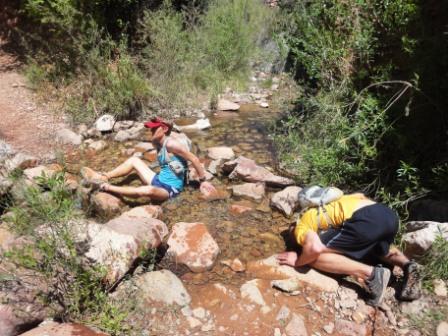
| it feels so good to sit |
 |
| huge thanks to Andy for pacing 57 miles! |
 |
| Me, Dad, Candie |
 |
| Jess and me relaxing post race |